Customer Portal
When the first R2Sonic multibeam was introduced, in 2008, the sonar had a maximum swath sector of 160°; the sector was variable from 10° to 160°.
The 160° sector was designed so the customer could survey vertical surfaces or slopes without having to physically rotate the sonar head; not survey the seafloor.
All other multibeams, at that time, had a sector size of only about 130°. Shortly after the introduction of the Sonic 2024, R2Sonic introduced the ability to orientate the sector to port or starboard, which greatly improved the vertical mapping capabilities of the sonar.
Back to the beginning, the 160° was not intended for seafloor mapping, but for vertical mapping.
The larger the sector, the wider the outer beam footprint becomes and the more acute the grazing angle; both factors imply the data, from the extended swath, will not be hydrographically acceptable.
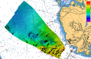
For seafloor mapping we recommend a maximum sector of 120° – 130° to make sure that all data is hydrographically reliable.
Customers who wish to survey at the full 160° because the sonar can go to 160° sector will end up getting less usable swath than if they had used a 130° sector. This is because the extended sector also laterally spaces out the beams to accommodate the larger sector, which means the beam footprint, at 130°, using a full 160° is much wider than if the sector was set to 130°.
As an example, in 15 metres depth, at 130° sector the outer footprint is 0.73m. With a sector of 160°, the footprint at 130° is over 4 metres.